As one of the leading rugged computer providers, Getac offers extensive rugged computing product lines and serves a wide range of vertical markets.

Getac Select
A combination of rugged computing devices, software, accessories and professional services in a purposeful range of specifically tailored solutions.
Getac Video Solutions
Video capture, evidence management, rugged hardware and robust software solutions for law enforcement and other industries.
Defense
Mission-critical COTS computing that delivers high powered processing and reliability in operational environments
Public Safety
Law Enforcement, EMS, Fire & Rescue applications
Utilities
Smart Meter Reading and Installation, On-site Safety, Utility Asset Management, Workforce Management for Utilities, Mobile GIS, Surveying and Mapping
Transportation & Logistics
Railroad Management, Airport Management, Port Management, Long-haul Delivery Fleet Management, Warehouse Materials Handling
Industrial Manufacturing
Industrial Programming and Robotic Control, Facility management, Compliance and Inspections, Workforce Management, Inventory and Warehouse Management, Factory Automation and Plant Monitoring, EAM and CMMS Solutions.
Automotive
Optimized Rugged Mobile Solutions to drive a smarter approach throughout the automotive value-chain.
Natural Resources
Mining, Forestry and Construction applications
Oil & Gas
Remote Support, Asset Management, Field Data Analysis, Workplace Safety
Most construction projects or land transactions involve a land survey.
Engineers perform a land survey to locate, describe, mark, and map the boundaries of contour lines and elevation changes. The result is a legal description used to buy or sell the land or to demarcate boundaries to establish ownership. Land surveys are the foundation of property rights and infrastructure development.
Land surveying is a historic profession, dating back to the construction of the great pyramids of Egypt. Professional land surveyors still use the same basic concepts of geometry, engineering, and physics to establish property boundaries. In modern construction applications, digital survey equipment is essential for accurate measurements in construction projects.
Today, digitalization has transformed the practice of land surveying, moving from sticks and strings to digital tools that increase land surveys' accuracy, speed, and efficiency. Trimble provides reliable and accurate surveying and positioning technologies, enhancing productivity and ensuring precise measurements for professionals. Rugged technology solutions support this transformation with greater reliability and connectivity that elevates the practice of land surveying into the digital age.

Digitalizing land surveying offers precise measurements, efficiency, data integration, and cost reduction as key advantages
The Egyptians used knotted ropes and plumb bobs for their surveys. Before the digital era, surveyors used transits and theodolites to site lines and record data manually. While manual surveying was surprisingly accurate, it could be slow and prone to errors.
Digitalization in surveying land delivers several benefits, including more precise measurements, efficiency and data integration, and lower land survey costs.
To determine a property's boundary lines, a modern professional land surveyor uses many digital tools, including GPS systems with satellite imaging, electronic distance stations, 3D scanners, theodolites, and drones. Theodolites are essential for measuring horizontal and vertical angles, providing unmatched precision and usability despite technological advancements. These assets help surveyors measure distances and angles precisely and quickly and interface with additional software to integrate data to create different types of land surveys.
The most common type is cadastral surveying, which establishes property boundary lines and dimensions. Cadastral surveys are applied in several use cases, such as a subdivision survey used to divide property, an ALTA survey to transfer title to property, or a land survey that establishes a property's boundary lines for the property owner. Related types of surveys, such as mortgage, construction, As-Built, Hydrographic waterway, mining, etc., can be generated with digital surveying and digital survey equipment only.
Surveys are often part of the public record, so even something as simple as recording the legal description of property corners is critical to mitigating boundary disputes or properly site construction projects. One of the benefits of digitalization for a land surveyor is the ability to easily share electronic versions of the property survey with enhanced maps and visualizations. They are critical for real estate transactions, and a real estate agent should ensure an up-to-date survey of any property they are selling. Title companies will require a property survey with legal boundaries as part of the title insurance policy for any residential or commercial transaction.
Modern surveying equipment has revolutionized how land surveyors and engineers take precise measurements. With the advancement of technology, surveying equipment has become more accurate, reliable, and efficient. Some key features of modern surveying equipment include:
The benefits of modern surveying equipment are substantial:
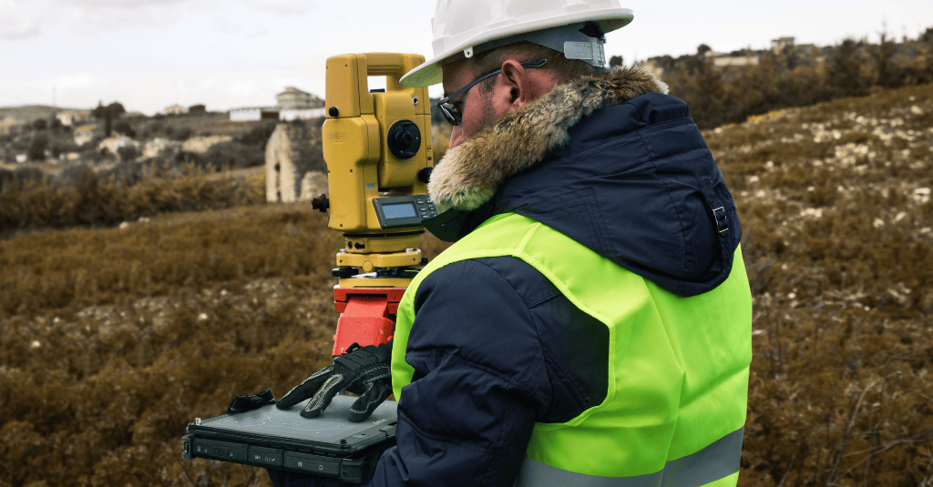
Professional land surveyors tackle outdoor challenges with rugged technology, ensuring land surveying continue even in harsh weather conditions.
Land surveying occurs outdoors, often in undeveloped locations that may be difficult to reach and offer little shelter in inclement weather. Surveying equipment must be rugged to withstand temperature and humidity extremes and rough handling. Commercial off-the-shelf options for devices, such as laptop computers or tablets, typically don't provide the durability and reliability that a professional land surveyor requires.
Rugged technology devices used in digital land surveying work include the following:
Global navigation satellite systems receivers (GNSS). Rugged tablets often incorporate GNSS receivers to record a location based on satellite data precisely. A GNSS receiver can connect with multiple satellite constellations, such as GPS and GLONASS, to complete the land survey.
Laser scanners. Laser scanners capture natural features and shapes and build structures to create 3D models to help visualize the land for architects, builders, and others who rely on the results of a land survey.
Total station. A total station is the modern digital version of a theodolite, an instrument used to measure vertical angles, distances, and angles with great precision. It can integrate with other digital devices to further analyze the data it captures for a boundary or As-Built survey.
Rugged tablets. Rugged mobile devices are designed to meet the demands of professional land surveyors, providing a trusted tool solution that delivers durability, reliability, and cutting-edge technological capabilities.
These digital technologies enable land surveyors to offer new services to the industry. For example, 3D laser scanners capture photographic reference points from multiple camera locations and integrate with data points from GPS and total stations to create accurate visual representations of how future site improvements would fit into the existing property surveyed.
Choosing the right surveying equipment for your needs can be a daunting task, especially with the numerous options available in the market. Here are some factors to consider when selecting surveying equipment:
By considering these factors, surveyors can select the right equipment that meets their specific needs, ensuring accurate and efficient surveying.
Land surveying business is an outdoor job, and rugged technology solutions address many common challenges that professional land surveyors face.
All types of land surveys must be completed in adverse weather conditions, including temperature extremes, rain and snow, full sun, high winds, moisture, and humidity. These conditions could delay the survey completion without the use of rugged gear.
Surveys may be required in rugged or unimproved terrain to identify land boundaries. Devices must withstand vibration and potential drops on unforgiving surfaces such as rocks and hard-packed soil.
To perform their duties in these harsh surroundings, professional land surveyors need rugged technology with the durability and reliability required to do the job. Long battery life ensures easy operation and uninterrupted data collection in the field.
The concept of rugged technology extends to cyber security as well. Commercial-grade rugged technology incorporates leading privacy and security measures to ensure data is secure and protected by high-level security, such as biometrics identification, with full access and complete control to protect mission-critical data.
Implementing digital surveying solutions can bring numerous benefits to land surveyors and engineers, including increased accuracy, productivity, and efficiency. Here are some best practices for implementing digital surveying solutions:
By following these best practices, surveyors can effectively implement digital surveying solutions, enhancing their projects' accuracy, reliability, and productivity.
Land surveying is a historic profession with a long legacy of precise measurements using tools and techniques proven over the years to establish property boundaries. Adopting digital land surveying and rugged technology solutions could be seen as disruptive to that legacy. Long-time professional land surveyors must learn to use rugged technology and digital land surveying techniques, which some may view as challenging. Also, new digital technology may require significant hardware and software investment to incorporate into the daily workflow. However, like in other fields, many benefits to adopting digital technology outweigh objections, such as cost and complexity.
Digitalization of land surveying is about more than technology. Incorporating digital technologies requires rethinking how the work is done and how the organization operates with new processes. A licensed land surveyor can leverage training and educational programs to get the most out of the latest technology and innovation and incorporate that into their organization relative to colleagues, customers, and other stakeholders. Ultimately, adopting rugged technology requires changing the mindset of the organization.
Technology continues to shape the future of digital land surveying, as emerging trends will play a more significant role in the industry.
Drones are among the most common additions to land surveying. With data capture through video and GNSS, drones offer the advantages of aerial photography and mapping to improve the efficiency and flexibility of land surveys – especially a topographic one. With drones, a land surveyor can collect and process more data in less time while avoiding the need to travel in potentially dangerous situations like a busy highway or mountainous terrain.
Lidar, or light detection and ranging, uses a laser pulse to map the terrain and the surrounding environment to create 3D models and maps of objects while traveling at (or up to) highway speeds. This innovation will make land surveying more time- and cost-effective. Lidar equipment can be carried on drones to generate a topographic survey and map property lines for a boundary survey.
Cloud-based data management centralizes all the data from surveys, making it available to any authorized user. Cloud storage can be sized dynamically, allowing surveyors to scale storage costs up and down depending on project needs.
These innovations will continue transforming the digital land surveying world, equipping surveyors and their clients to save time and costs.
Rugged technology solutions are the foundation for the digitalization of land surveying trends. With digital solutions, land surveying can be completed faster, more accurately, and with a higher level of safety. Rugged technology supports this trend with gear designed to function in extreme environments with the durability and reliability that professionals require to do the job.
By embracing digital workflows and rugged technologies, professional land surveyors can provide more accurate information faster, with additional visualizations to facilitate communication and feedback with their stakeholders.
As one of the leading rugged computer providers, Getac offers extensive rugged computing product lines and serves a wide range of vertical markets.
